Research
We aim at improving understanding and prediction of geographical systems by innovating methods and tools. Our research is at the intersection of three domains (see below).

Methods & Software Development
We design methods and implement software for simulation of large, heterogeneous geographical systems:
Representation of fields and agents in simulation models to enable heterogeneous system modelling
Simulation on supercomputers to run models with big data
Model data integration techniques to constrains models to observations
Projects:
LUE Environmental Modelling Software enables storage of heterogeneous spatio-temporal data, that is both continuous fields and discrete, mobile, agents. We are currently working on the development software that will enable reading and writing data to the data model and for manipulation of the data stored.
PCRaster, spatial simulation model building framework
GREAT, The Green Deal Data Space Foundation and its Community of Practice, EU project, 2022-2024.
Key publications:
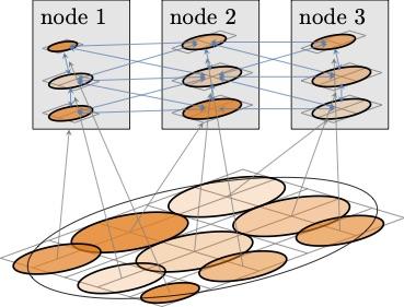
Distribution of calculations across nodes of a supercomputer.
Complexity Science and Data Science
Due to their intermediate number of interacting system components, most geographical systems show distinct mechanisms, such as self-organisation and critical shifts, that categorizes them as complex systems. It is essential to understand these mechanisms because they are central to system behaviour and thus essential to prediction, including the analysis and reduction of uncertainty in prediction. Our team explores complex geographical systems by simulation modelling and through statistical and machine learning techniques on large geographical data sets.
Projects:
Data driven discovery of time transfer functions for hybrid simulation modelling. Postdoc project.
Key publications:
Geographical Systems
We use complexity science and data science methods and tools to advance our understanding of geographical systems, with a particular focus on human-environment interactions and global scale assessment.
One of our research foci is the external exposome (wiki) which encompasses all human exposures to the the environment. It is known to be an important determinant of health and disease. As direct measurement of the external exposome is mostly not feasible, research in exposome-health relations needs to rely on estimations of external exposures through modelling. This requires quantification of the environmental variables (e.g. air pollution, green space) as well as human space-time activity trajectories within this environment. We cooperate with health researchers, epidemiologists, and risk assessment researchers in a number of projects. Our role is the innovation of external exposome modelling.
In addition we use spatial simulation models for land use change, ecosystem services, (global) hydrology, geomorphology and related processes.

Projects:
The Global Geo Health Data Center creates data sets and software for assessment of human exposures to our environment, for instance air pollution, urban food landscape, or green space. Our team cooperates with epidemiologists and risk assessment scientists to improve our understanding of the role of the external Exposome in human health and disease.
Exposome NL. Gravitation programme funded by the Dutch Science Foundation. Multiple partners, 2020-2028.
Accounting for mobility in air pollution exposure estimates in studies on long-term health effects. Project in cooperation with Swiss Tropical and Public Health Institute, Basel, Switzerland, and Institute of Risk Assessment Sciences, Utrecht University, the Netherlands.
GoNEXUS. Water Energy Food nexus research project, Global Hydrology project with contributions from our team.
Multi-model seasonal prediction system (ULYSSES), UU components coordinated by Niko Wanders with our involvement.
How much groundwater is there, and how long will it last?; Global Hydrology project coordinated by Marc Bierkens with contributions from our team.
Water scarcity under droughts and heatwaves: understanding the complex interplay of water quality and sectoral water use, NWO Vidi project of Michelle van Vliet with contributions from our team.
Key publications:
Sociology of Environmental Model Construction
Projects:
Mediating models: implications on scientific research and communication, PhD project of Lucie Babel. With Dominique Vinck (Institut des Sciences Sociales, Faculty of Social and Political Sciences, University of Lausanne, Switzerland).
Key publications: